
!!!!CANCELLED/POSTPONED!!!
IT IS SNOWING UP THERE NOW AND FORCAST FOR 7-11″ TONIGHT AND ANOTHER 3″ TOMORROW WITH RAIN THROUGH SUNDAY. FREE DINNER STILL HAPPENING AT SUBCULTURE 5-6 TOMORROW (FRIDAY). FUTURE DATE TBD.
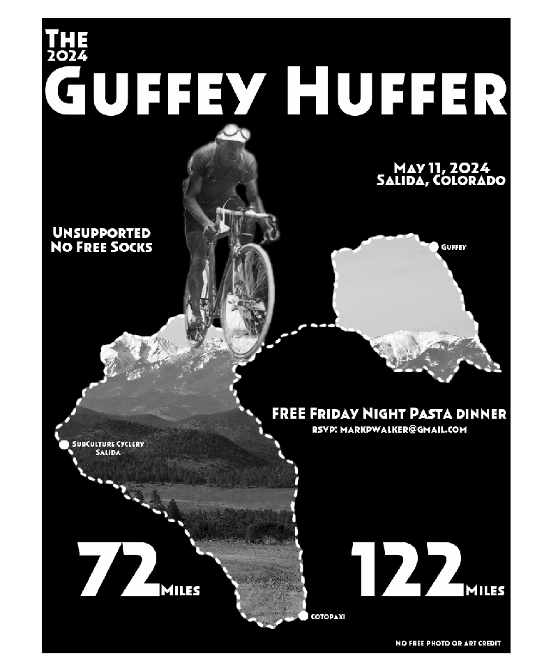
May 11, 2024 -Salida, Colorado
If anyone has any questions about the ride please contact me through my email at the bottom of this page.
Please make sure to read all rules for this. This is fully unsupported and you will need to be self-sufficient in order to complete this. The rules are located HERE.
No more than 74 people allowed for this event!
This is intended to be NON-COMMERCIAL, Recreational-Use Activities that are held on parts of USFS lands in compliance with USFS Special Use Rules and Regulations.
THE GUFFEY HUFFER
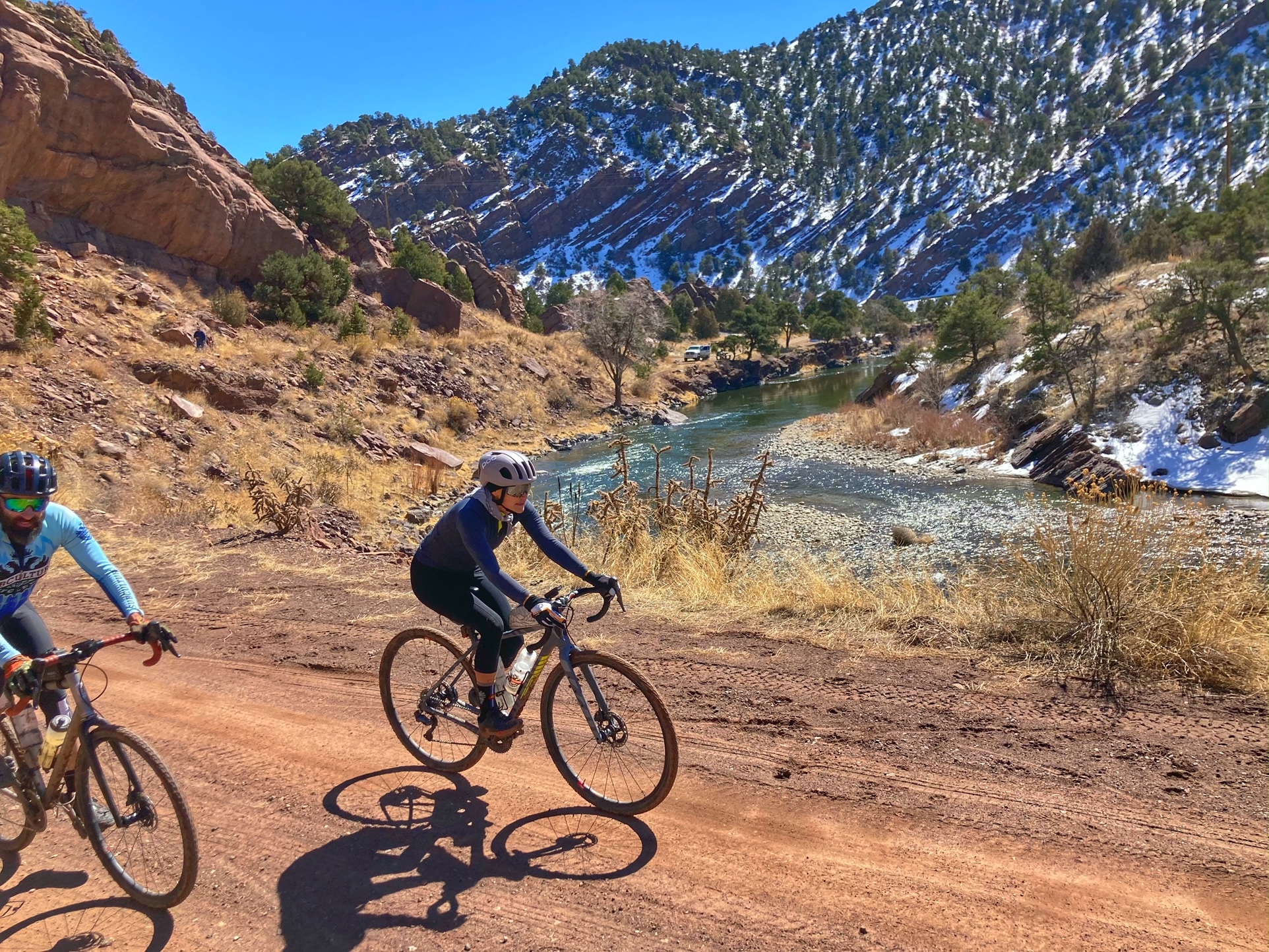
This is a down homie kind of event. No frills and no free socks. Times will be kept and recorded but is this a race? That is up to you. There are some short sections of highway on each route. Blinky lights and other hi-vis gear recommended, SINGLE FILE ONLY ON HIGHWAYS. Meet and ride with new folks, enjoy the scenery, have a coffee and/or hamburger and “Be Cool Hunny Bunny”.
ALTERNATIVE 72 MILE ROUTE
Firebox Loop–72 mile option.
If you are wanting to grind some gravel, but save a little for the
next day, check out the Firebox Loop. Starts at the same time and
finishes at the same place at the Guffey Huffer. Stay
on CR2 for almost 23 miles from the start and turn right on Firebox
Road. This turn is about 1 mile past the intersection of County Road
12 and County Road 2. Stay on Firebox Road, it will turn into County
Road 12 part way up your first climb, just stay straight. A few big
rollers on County Road 12 then a long descent with a bit of pavement
before getting to the Arkansas River and the town of Cotopaxi at about
50 miles. There is a great general store in Cotopaxi and the nice
ladies there will make you a sandwich or hamburger at the deli. Then
a few miles of Highway 50 to Coaldale. Turn left up Hayden Creek Road
and about a 1/4 mile turn right on County Road 45. Cross Highway 50
and Vallie Bridge and stay on County Road 45. There is a water
crossing with about 10 miles to go at Badger Creek. Go down the hill
to the creek, TURN LEFT AND RIDE DOWN THE CREEK for 50 feet and then
turn right up the short steep hill to regain County Road 45. Stay on
45 to Wellsville, cross the river at the bridge and you have 4 miles
of Highway 50 to the Stockyard Bridge. Turn right at the Stockyard
bridge then left before the railroad tracks and head back in to Salida
to Subculture. 72 miles with about 6100 feet of climbing. This ride
is mostly good gravel roads with some rough rocky bits in the last 15
miles. A good portion of the ride is between 9000 and 10000 feet.
Here is the Garmin Course for the 72 mile Firebox loop
https://connect.garmin.com/modern/course/54927032
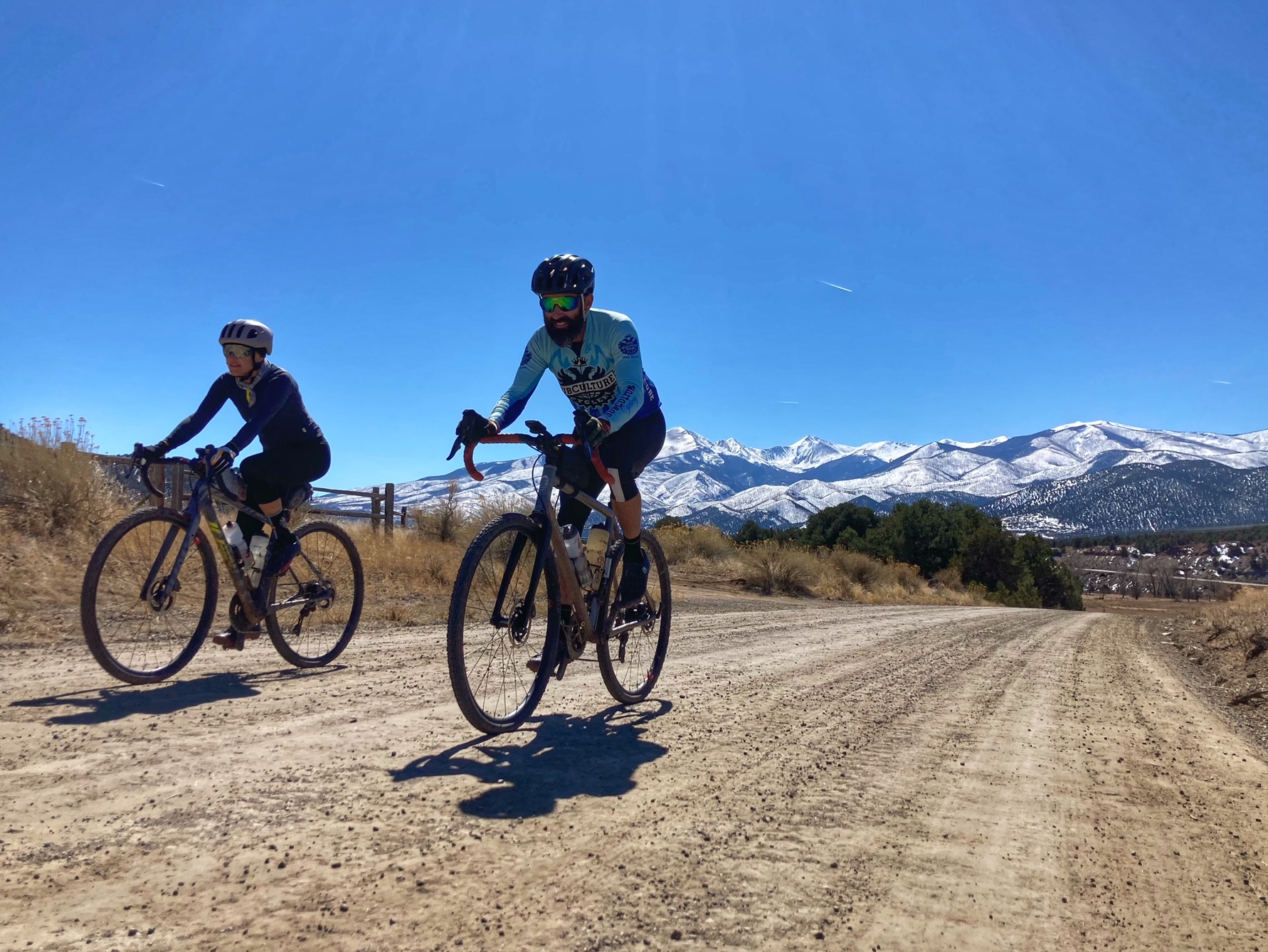
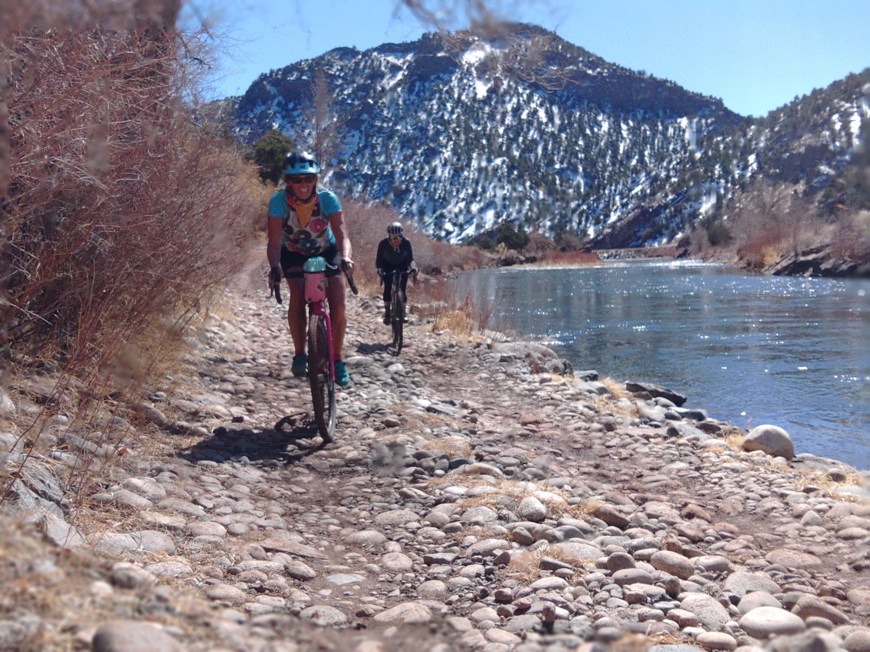
Photos by Taf McMurry
If you have questions contact me –(markpwalker@gmail.com).*****
START: Meet 6:45 AM in SALIDA at SUBCULTURE CYCLERY, roll out 7:00 AM sharp! We’ll have coffee. Restrooms are available at the Start.
PARKING: Please park in the Parking Lot on the west side of ‘G’ street, by Subculture Cyclery or in the Free Parking Lot west of Safeway or the free lot across the F Street Bridge

FINISH:* BACK @ SUBCULTURE CYCLERY. Whenever you arrive back in town please SIGN OUT at the Finish. Bike wash, showers, beer and some food provided for riders after the ride, everyone is welcome.
LODGING: There are a number of hotels in the area. Local favorites are The Simple Lodge and Hostel , and The Woodland both just blocks from the start.
Course Description for the Guffey Huffer
GPS use is highly recommended.
– Start at SUBCULTURE CYCLERY, Neutral Rollout across the bridge to CR 175. Go Right on CR 175 and begin the climb. After a mile this paved road turns to gravel. Around 8 miles take the right turn, (uphill) staying on CR 175. Around MM 12 Cross the county line and the top of the first climb. At about mile 29 you will turn left on C.R. 2A which turns into C.R. 88 and ride to Highway 9. Turn right on Highway 9 for about 2 miles and you will see the sign to Guffey, a left hand turn. You DO NOT need to go into the town of Guffey , Mountain Aires Market is at the corner of C.R. 102 and Highway 9, they are open 9am-4pm. They have a great selection of organic food, bulk items and sport/ride food. They are super nice. If you are only getting water, please try to buy something. Guffey is about 1 mile up C.R. 102 (paved) if you choose to go there. Continue south on the pavement for about 10 miles to Tallahassee Road/C.R. 2 (big sign) and turn right (dirt). At about mile 60. right after a decent with a switchback, turn right at the intersection to Salida (sign “to Salida”) DONT MISS THIS TURN. At mile 77 turn left on Firebox Road and follow the Firebox Loop course back to Salida.
Here is the Garmin course for the 122 mile Guffey Huffer
https://connect.garmin.com/modern/course/94572061
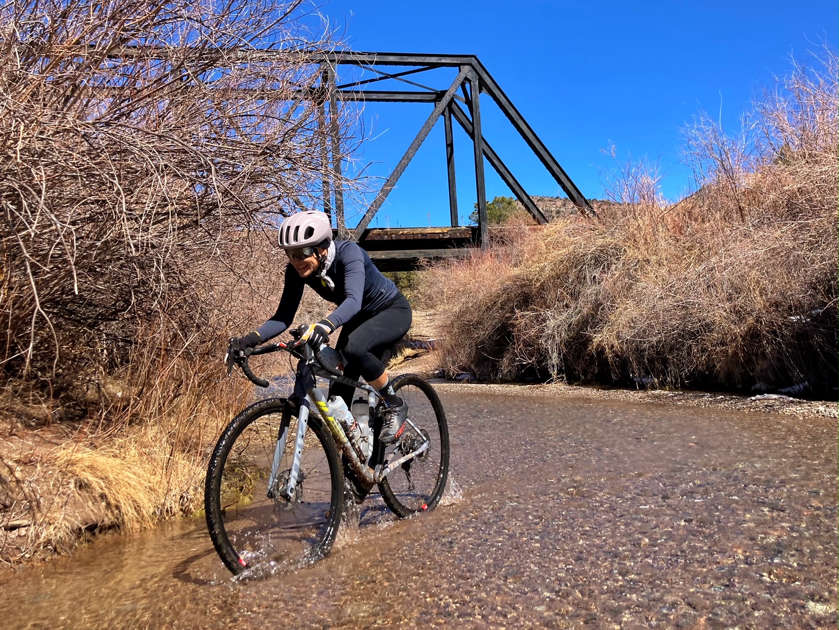
Top Photo by Taf McMurry
Tips and recommendations for success…..
- Gravel bikes recommended . If you show up with a road bike and 25c tires, you’re not really going to dig it to much.
- Prepare for a day of big miles at altitude. Bring extra food, water and money to get you home.
- Bring warm clothes and rain gear. Most of the ride has exposure to high winds and the spring rains and snow common in the South Park.
- Put your cell phone in airplane mode/turn it off. Service is spotty and your battery will drain.
- DO NOT EXPECT any kind of bail out, sag wagon, sweep or rescue, study the map and have a bailout plan. YOU ARE ON YOUR OWN, FULLY RESPONSIBLE FOR YOURSELF.
- Prepare to have a good time with like minded folk with splendid views along the way.
- Contact me with any questions markpwalker@gmail.com. I can also send you a GPX file if needed. For some reason I could not upload it to this site.

April 29th, 2013 at 8:02 pm
I’ve looked at all the various pages associated with the event and can’t find where I can download the cue sheets for the ride. Am I missing it?
Thanks,
Nick
April 30th, 2013 at 6:32 pm
http://www.bikeroutetoaster.com/Course.aspx?course=473565
top left of page is a tab for cue sheet.
May 6th, 2013 at 7:00 am
Thanks!
May 11th, 2015 at 5:52 pm
I think you can export a GPX from the bike route toaster link under the garmin one.
May 19th, 2017 at 6:29 am
The ride is still on, no major amounts of snow. We have had some moisture the last few days, could be a little muddy here and there. I have also posted an alternative 70 mile route that is good too.
June 7th, 2017 at 5:00 am
How to ban a person from a blog on blogspot?
June 21st, 2017 at 3:41 pm
[…] Follow the official route up and over Boreas Pass, through Como, across the northern part of South Park and into Hartsel. You’ll get a feel of the vibe of South Park on this stretch. If you’d like things to be a little more interesting: narrower roads, more climbing, more varied terrain, and a little longer distance take this next alternative – it’s based on a local underground race called the Dirty Double Fondo: […]
November 30th, 2017 at 5:22 pm
I blog often and I seriously thank you for your content. Your article has truly peaked my interest. I am going to book mark your site and keep checking for new details about once a week. I opted in for your RSS feed too.
August 22nd, 2018 at 8:01 pm
Similarly to Knight and Day from earlier this summer, once the second half rolls around, most of the appeal is lost, and the movie becomes more of a financial thriller than a buddy-cop comedy.
March 24th, 2019 at 8:04 am
Betsy and Andy are in
February 26th, 2020 at 11:37 am
Any word on a date for 2020?
May 13th, 2021 at 10:48 am
Mike Richardson
May 13th, 2021 at 11:29 am
Will & Abby Scheel
February 8th, 2023 at 7:40 pm
Are we on for 2023?!
March 22nd, 2023 at 11:19 am
It’s on. Web page has been updated. The socials will come soon.
February 12th, 2023 at 1:11 pm
Also interested in ’23 – any way I can volunteer to help remotely to get the ride happening?
March 22nd, 2023 at 11:21 am
Hi Justin. It’s on. Web page has been updated and the socials will come soon. Thanks for the offer for help. How ’bout a calm day, sunny with no snow or mud. You will get an extra hamburger at the finish if you do this for us.
March 22nd, 2023 at 11:42 am
YEAH! I’ll talk to guy upstairs.
March 12th, 2023 at 8:13 pm
I am interested as well might be able to rally a few other souls.
March 22nd, 2023 at 11:22 am
Hi Chris. May 6. The website is updated and the socials will come soon. All are welcome.
March 23rd, 2023 at 8:39 pm
Thanks looking forward to it!
March 22nd, 2023 at 12:32 pm
In for 2023
March 22nd, 2023 at 4:52 pm
Rafael Millan-Garcia is in for 2023
thanks gang!
April 15th, 2023 at 7:51 pm
blake is in for 2023
April 17th, 2023 at 8:24 pm
Hernan Avella and Aaron Terteling IN!!!!!
April 18th, 2023 at 4:48 pm
In for 2023
April 27th, 2023 at 10:19 am
Count me in!
April 27th, 2023 at 10:25 am
Brandon Snider
April 29th, 2023 at 8:03 am
Team Have Fun is in!
April 29th, 2023 at 8:41 am
James Fenwick is in!
May 2nd, 2023 at 4:38 pm
Michael Hill will be there…either the Firebox Loop…or a modified version of it with a few extra miles.
May 2nd, 2023 at 6:45 pm
Teresa garcia is in
May 3rd, 2023 at 8:00 pm
Jace Stout & Haley Dumke in for 2023!
March 12th, 2024 at 5:44 am
In
May 6th, 2024 at 7:00 am
Is this still happening this coming Saturday? I’m interested.
May 6th, 2024 at 9:10 am
In for 2024 – Christopher Bryant
May 6th, 2024 at 1:49 pm
Nathan Collier is IN for 2024! I have been emailing with the race director, Mark, and this event is on. I know the link for registration on the home page is incorrect, but I was assured this is very much still happening. I guess a lot of locals just show up without registering, so they don’t depend on registration to keep account? Not the usual structure I’m used to on Colorado Endurance Series events, but it’s all cool. 😎 I’ll be the crazy person on the 28c road bike. 😁
May 9th, 2024 at 2:25 pm
I’m going to keep checking the weather, but I have zero clearance for any kind of mud. 😬 80% chance of rain & snow Friday, 60% thunderstorm Saturday…. 90% chance I bail.
May 6th, 2024 at 4:30 pm
Paul Mourer & Kristy Ochipinti in for 2024!!
May 9th, 2024 at 5:54 am
Weather is looking….sub-optimal.
May 9th, 2024 at 6:30 am
Opting out with the questionable weather. Next year
May 9th, 2024 at 3:00 pm
THE RIDE IS CANCELLED/POSTPONED. OVER A FOOT OF SNOW IS FORCASTED ON THE UPPER PART OF THE ROUTE AND WEATHER NO GOOD ON SATURDAY. FUTURE DATE TBD.